|
1415
Panoramic view of the Agincourt battlefield
I visited the battlefield in the summer of 2008. It is a tricky landscape to describe: there are no dramatic features that mark it out. But nor is it flat or without strategic significance. As a result I took a large number of photographs of the site, particularly from the field called la Cloyelle, which is just north of the English encampment at Maisoncelle, where the English spent the night of the 24th October 1415. One series of these appears in the book - showing the view south from the French lines in one picture and the view north from the English lines in another. These were edited together by my cousin, the artist Stephen Read, to whom I am very grateful. Stephen also edited a long sequence of ten photographs, giving a full 360-degree view of the battlefield in two parts, which is available here.
The south of the battlefield (first English position)
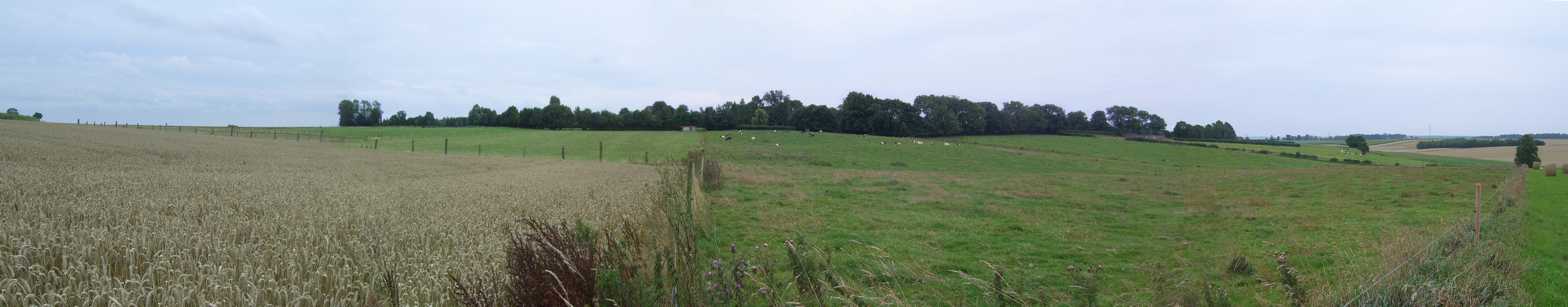
The image above is a 180-degree view southwards from la Cloyelle, standing about a third of the way into the field, on the western side of the battlefield. (Click here for exact position.) It shows the ground where the English drew up, probably behind the gradual dip (which may have been more pronounced at the time). From here they advanced towards the French lines, after a long delay. Behind the trees is the village of Maisoncelle, where the English camped in the barns, houses and gardens before the battle. The fence on the right of the picture is aligned southwest, where there is a noticeable falling away of the land, making it harder in the wet conditions for the French horses to charge from the wings. On the extreme left of the photograph (the north-east side) is a slightly raised grassy bank which can be viewed more fully in the next picture. A more detailed, high-res view of this end of the battlefield is available if you click anywhere on the above photograph (but note this file is 4.9Mb).
The north of the battlefield (towards the French position)
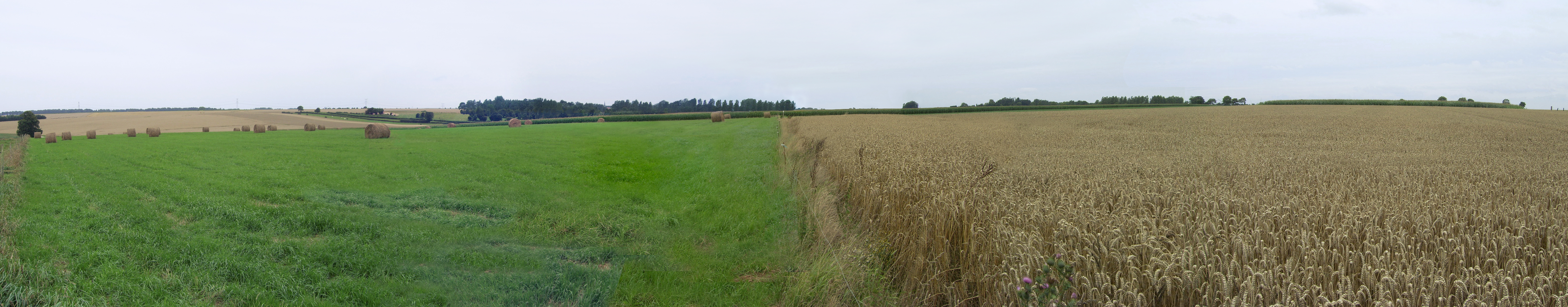
The image above is a 180-degree view northwards from la Cloyelle, standing at the same point from which the previous picture was taken. On the right (east) is the centre of la Cloyelle, with a grassy bank at the height of the hill. Behind this is the village of Tramecourt. The village of Azincourt lies behind the tress in the centre left of the picture. Slightly to the right of these is a lone clump of trees in which stands the nineteenth-century memorial, supposedly built on the site of a mass grave of French victims (the English dead were piled in barns along with surplus captured armour and burnt). If this clump does indeed mark a mass grave, then it is probably not far from where the majority of the French men-at-arms fell, and so marks a position not very far forward of the original French lines. A more detailed, high-res view of this end of the battlefield is available if you click anywhere on the above photograph (but note this file is 6.7Mb)
- Synopsis
- Prologue (from the book)
- Panoramic view of the Agincourt battlefield
- Reviews
- About writing the book
- UK Publisher's website
- Buy ebook from USA Publisher's website
- UK audiobook (narrated by James Cameron Stewart)
- USA audiobook (narrated by James Cameron Stewart)
- Original hardback cover
